Entry #16: Mile 25, Sharon. The Old Roebuck Road

The Old Roebuck Road
The Old Roebuck Road was the original path leading from Massachusetts Bay to Narragansett Bay, and it existed prior to the arrival of European settlers. The original trails in the area were used by the Indians of southern New England as they followed the seasonal movements of game and fish. This particular trail linked two especially productive areas under the control of the Wampanoag and Massachusett Indians. John Winthrop Jr. followed this trail on his return from New London to Boston in 1640, and countless others used this route in the subsequent century. The Roebuck Road became known as the Post Road about 1700 as the postal riders followed the route from Boston to the important coastal towns of Newport, Providence, New London, New Haven, and New York. As I mentioned in the last entry, the section of the route from Boston to Rhode Island moved west in the middle of the eighteenth century as new and better quality roads cut the distance and improved the quality of the trip. The original route then became known as “Old Post Road,” or sometimes as the “Old Country Road.” Today the road passes through some of the least populated areas south of Boston, and sometimes even becomes a dirt path in the forest. Time has passed this road by. As Norman Bates put it so succinctly in Hitchcock’s Psycho, “They moved away the highway.”
In some sense it’s neglect makes this section of the route more interesting as it represents to me the closest approximation of the actual conditions Sarah Knight might have found on her journey in 1704, or the route Metacom might have traveled three decades before. At the point where the two roads from Boston to Providence diverge in Norwood, the Old Roebuck Road can be followed for twenty miles until the older and newer roads reunite in the town of North Attleborough. In this entry I will trace the remnants of this route and look for evidence of the former “glory” of one of the very oldest roads in America.
*****
Neponset Street in Norwood is a suburban residential street, lined with ranch houses often flying American flags and well kept yards with ubiquitous “Mary in a Bathtub” statues. The driveways are generally populated with large Ford and GM vehicles. In short, it looks exactly like the neighborhood in Braintree where I grew up. The population of Norwood is 28,172 (2007 census estimate) in an area of 10.6 square miles, so it is a moderately densely populated town, typical of the suburbs closer to Boston. 91% of the population is white, and 35% list themselves as Irish-American while a further 15% list themselves as Italian-American. As I discuss in the next entry, Norwood is a more conservative town than Boston but much less so than the towns further south. The houses, yards, cars, and people I see on the street reflect the data I just provided.
Neponset Street intersects Pleasant Street after three quarters of a mile, and the Old Roebuck Road veers right onto Pleasant Street. From the intersection of these two streets I am only a few yards from US Route 1, lined with strip malls and, almost directly across from where I am standing, is the curious Norwood Country Club, the only golf course I have ever seen with its clubhouse in a strip mall. The course itself is built right in the middle of the vast Neponset (formerly Purgatory!) swamps, and after a rainy day, playing here is like playing in a swamp. As a golfer, I recommend this course only if you are desperate or want to get an artificially low score, smashing the ball down the dead straight and flat fairways. My lowest score on a regulation eighteen-hole golf course (81) was achieved on this course, eight strokes lower than any previous score at any other course. Just think how good it would have been if I were able to putt well.
Pleasant Street in Norwood runs the length of the town and is lined with the same suburban houses I have just described. So far this walk might be charitably called dull, although the elevation of the road surprisingly rises and falls fairly sharply. After a mile and a half of this landscape, which bypasses the commercial center of Norwood completely, I arrive at the first interesting place on this part of the walk. The Neponset River was originally crossed here by wading through its relatively narrow width. In 1652, the selectmen of the town of Dorchester (this area on the eastern side of Norwood was originally part of Dorchester) approved the construction of a “bridge over the river of Norponsit in the way leading from Dedham unto Rehoboth [the area currently called East Providence, RI] sufficient and stronge the said bridge to be fower foote in bredth ...with a rail on either side about twoe foot and a half high” (1). A tavern run by Henry White existed near the “Kings Bridge” as early as 1688 and is mentioned in Tulley’s Almanack of 1698 as six miles from Fisher’s Tavern in Dedham, although I measure it at 6.7 miles distance from Fisher’s Tavern (2). Samuel Sewall visited the tavern in 1702, and Knight must have passed it in 1704 in her effort to meet up with the postal rider at Billings Tavern, although she does not mention it. Win Everett, in Tales of Tiot, relates a record of expenses found in the Colonial Society of Massachusetts dated 1688 that lists spending one shilling four pence (16 pence) “Att White’s.” (3) Flip, a popular drink of the time in New England containing rum, sugar, eggs, and beer, stirred with a hot poker to foam it up and served in a three to four quart glass tumbler (I am not kidding!) generally cost about nine pence; even a gallon of rum purchased in 1740 in Philadelphia cost one shilling eight pence (20 pence). Either he stayed the night and ate a meal, or he drank an awful lot.
According to Willard DeLue, in The Story of Walpole, in 1718 the first stagecoach line in New England followed this route from Boston to Bristol (formerly in Massachusetts but now in Rhode Island), where passengers could continue by boat to Newport or New York (4). The fifty-five mile trip took from 5 a.m. Tuesday to noon on Wednesday in 1720 and was made every two weeks in summer. (Boston Newsletter, Ap 1720). By the 1750s the stagecoaches were traveling the newer road and the word “Old” already appeared in the name of this road.
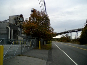
Norwood became a separate town in 1872 as its population increased during the nineteenth century as a result of the industrial expansion that accompanied the arrival of the railroad. As I cross the Neponset River the road passes a cement factory and other factory buildings. They seem a bit forlorn and out of the way, and the road itself becomes less inviting, often lacking the sidewalks that I have generally been able to count on.
*****

Above: Survey of the area of the Neponset River in present Norwood and Walpole done in 1688, showing the “Ponset Bridg” and “The Contry Road.” Also shown is the boundary between the original “mother towns” of the area, Dedham and Dorchester, as well as a small tract of land between the road and the border “Reserved” for the Wampanoag Indians, who once lived in almost 1000 square miles of the surrounding area. To the right of the road are “all vacant lands” which today are filled with the strip malls and office parks of US Route 1. Source: Dorchester Historical Register, IX, April 1898, page 45.
Below Left: “King’s Bridge” today over the Neponset River, with view of the river from the bridge below right.
One mile beyond the Neponset River brings me to Walpole. In the previous entry I traveled through Walpole Center. This road traverses East Walpole, a much less populated and more bucolic area. Half a mile from the border with Norwood I pass Bird Park, a property managed by the Trustees of Reservations , ninety acres of beautifully landscaped parkland that is truly lovely. Directly opposite Bird Park at Coney Street, is the site of another tavern mentioned in an almanac, this time the Vade Mecum of 1732 (5). Coney’s, also known as the Roebuck Tavern was known to have been in existence by 1718 when Samuel Sewall paid a visit. I am uncertain why there should be two taverns so close to each other, but perhaps they were not in existence at the same time.
Five minutes walk further on I come to an exciting junction. Pleasant Street divides into two roads, the left one called Moose Hill Road and the right one called Old Post Road! I am officially on an actual road called Old Post Road for the first time. At first the road is fairly nondescript, similar in many ways to the suburban landscape I have seen for most of the day. After a mile and a half, it becomes very interesting. At Old Carriage Lane in Walpole the road disappears as it reaches a forest. I look into the woods and spot a trail that clearly is a continuation of the road. I follow this trail into the woods. After a few minutes I realize I am walking right through the Walpole Country Club golf course. I actually walk on the cart paths alongside a couple of the holes, quickly and nonchalantly as I am sure this is private property, until I reencounter the path into the woods again. A few minutes later I reemerge onto a street called Baker Street, which veers left. Almost as soon as I start on this road, I cross into the town of Sharon, where the street again becomes Old Post Road. A closer look at a map reveals that the border between Walpole and Sharon follows the very path I walked on through the woods, and continues to be the border for another few hundred yards, until Old Post Road intersects with BOTH US Route 1 AND Interstate 95. In the space of a half a mile I have walked on part of the road where it seemed to resemble something close to the original path and now I encounter the modern roads that recapitulate for the modern driver this most important main-travelled route in New England.
*****
Top Row: Left, Industrial scene in Norwood near the Neponset River. Right, Town Line.
Middle Row: Left, Old Post Road in East Walpole. Right, Old Post Road School and trees.
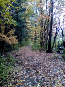
Bottom Row: Old Post Road meanders into the woods at the Sharon/Walpole line, then emerges from the woods in a rural area of Sharon. After a short while it reenters the woods in Sharon (photo at beginning of this entry).
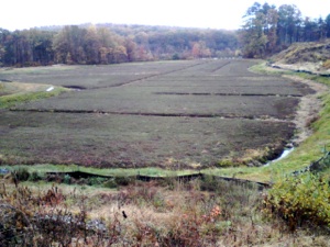
The Old Post Road, as it meanders through the western edge of the town of Sharon, is the most evocative and enjoyable portion of the entire trip to date. For half a mile after we pass under the interstate highway Old Post Road meanders through increasingly rustic suburban areas. The houses are sometimes farms with beautiful gardens and sometimes rundown ranch houses with couches on the porch and one with a tireless car on bricks in the driveway. I even see a Rebel Stars and Bars flag- I am unsure whether or not I am an extra on The Dukes of Hazard. At a turn in the road I see a path that trails off into the woods. I follow this and I enter Moose Hill Audubon Wildlife Sanctuary , 2000 acres of woods, swamps, rocky outcroppings, and tranquility. The Old Post Road runs in a generally straight line along the southwestern edge of Moose Hill. Eventually the path emerges from the woods onto South Walpole Street, where a sign put up during the bicentennial in 1976 commemorates the Old Post Road. Across South Walpole Street, Old Post Road continues for a half a mile as a paved road. I walked this route ten years ago, and it became even more interesting at this point as the road again became a dirt path that bordered a beautiful cranberry bog and continued up a small incline to reach South Main Street at the Sharon/Foxborough line. As I approached the same area on this walk I was shocked to find that, where there used to be a dirt path there with woods on one side and a bog on the other, there is now a gigantic construction site with fencing all around it from the spot where the dirt path once commenced all the way to South Main Street. I passed through the unlocked entrance, past the KEEP OUT sign as there was little evidence of any active construction. It seemed that the workers had moved tons of dirt around and then stopped in their tracks after destroying the beautiful scene I had encountered a decade earlier. All the trees that formerly bordered the bog had been removed, and the construction equipment looked poised to renew their energetic demolition activity, but it was quite apparent that the project had stopped. Subsequent research indicated that a large condominium and shopping complex was to be developed at the site but that construction had ceased due to the collapse of the economy in late 2008. My research suggests that the entire project was undertaken under somewhat dubious circumstances, but I will refrain here from engaging in a battle with the rapacious real estate development mafia.
On the bright side, the cranberry bogs, which are referred to as Paradise Cranberry Meadows in one local history book (6), remain relatively intact. However, according to the minutes of the Sharon Conservation Commission from February 15, 2007, the developer deeded the cranberry bogs to the town in exchange for changes in the zoning laws. You cannot make this stuff up. Quite a few citizens of the town of Sharon had apparently complained that too high a percentage of their taxes were paid by residential taxpayers rather than commercial taxpayers. So they pushed for more development in order to lower the tax burden on residential taxpayers. The town voted 2-1 to approve the zoning changes, allowing the developer (Intoccia Company) to start tearing up the former cranberry farm. Only after destroying the landscape did the developers announce that construction would be delayed because they were unable to find any anchor stores or grocery stores willing to join the development . This occurred in the only town in the area to vote overwhelmingly for Barack Obama in 2008, and one of a handful of towns south of Boston to support Martha Coakley in the 2010 Senate Election . I shudder to think what the people in a town like Wrentham or Norfolk would do in a similar situation.
*****
I scrambled through the debris of the construction site and retraced my original steps as best as possible to reach South Main Street. Sharon was originally the Second Parish of the town of Stoughton (which in turn was originally part of Dorchester), and near this spot once stood the Billings Tavern listed as being in Stoughton seven miles from White’s along the road from Boston to New York in Tulley’s Almanack of 1698. It is the same Billings Tavern that Sarah Knight was so desperate to reach on the first night of her journey in 1704. Knight, as was her custom, was unimpressed with the quality of the food and of the service she received at Billings Tavern:
“ ...shee [the eldest daughter of the the family, Zipporah Billings, who two weeks later was married to Samuel Man of Wrentham, who ran Mann’s Tavern discussed in the last entry] treated me very Rudely...she conducted me to a parlour in a little back Lento, wch was almost fill’d with the bedsted, wch was so high that I was forced to climb on a chair to gitt up to the wretched bed that lay on it; on wch having stretched my tired limbs, and lay’d my head on the Sad-coloured pillow, I began to think on the transactions of the past day.” (7)
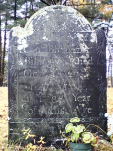
To my left, as I emerge onto the street from what used to be Old Post Road, is a small cemetery. Another bicentennial wayside indicates that this is the Old West Cemetery. In the cemetery is a grave with great significance to my project of rediscovering the Old Post Road. The grave of Ebeneezer Billings, the owner of the Billings Tavern for more than half a century who died in 1758 at the age of eighty, sits in the middle of the small graveyard. A tavern existed in this remote area as early as 1658. Roger Billings was the first colonial landowner in the area, possessing 700 acres in 1682 which he passed on to his two sons upon his death in 1684. Roger Billings’s other claim to fame in relation to the Post Road is that he was one of the two individuals granted the right in 1652 to build the King’s Bridge in Norwood that I crossed a couple of hours ago. (8). The original tavern, called Wainman’s, was located on property deeded to Ebeneezer Billings, so his tavern must have been a successor to the original, as there were few inhabitants in the area even in the eighteenth century. Judge Samuel Sewall visited the tavern almost annually on his circuit tours of the colony, and he missed Sarah Knight’s visit by only two weeks in 1704. The tavern stood on the opposite side of the street from the cemetery, where today stands yet another shopping mall. No comment.
In Tulley’s Almanac of 1698 Billing’s Tavern is listed as seven miles from White’s at the bridge over the Neponset River, which in turn is six miles from Fisher’s in Dedham. Fisher’s is listed as ten miles from the Boston Town House. Give or take a half mile here or there, Sarah Knight would have traveled twenty-three or twenty-four miles to reach Billing’s Tavern on Monday October 2, 1704. I have traveled, with slight detours resulting from changes in the path, about twenty-five miles to get to this point, including almost eleven miles today. As this entry is becoming quite lengthy, I will pick up the rest of this segment of the journey, from Billing’s Tavern at the Sharon/Foxborough line to North Attleborough in the next entry.
Above left: Cranberry Bogs in Sharon. The Old Post Road skirted these “Paradise Meadows” for centuries until a large construction project obliterated the road recently. Above Right: Grave of Ebeneezer Billings, owner of Billing’s Tavern, in what is now Sharon. This lonely outpost represented roughly the halfway point between Boston and Providence Rhode Island. The grave is in the Old West Cemetery a few yards away from the bogs and from the site of Billing’s Tavern.
Wednesday, June 23, 2010

Walking the Post Road
Old Post Road as it traverses Moose Hill Wildlife Sanctuary, Sharon, MA.
-
1.Dorchester Historical Review IX, April 1898, 45-47.
-
2.Early American Imprints: John Tulley’s Almanac, 1698. (Boston, Printed by Bartholomew Green and John Allen. Sold at the Printing House at the South End of Town, 1698.) Evans #854.
-
3. Win Everett, Remembering Norwood: Tales of Tiot, ed Heather S. Cole, Edward J. Sweeney. (Charleston, SC: The History Press, 2008), 111.
-
4.Willard DeLue, The Story of Walpole (Norwood, MA: Ambrose Press, 1925), 212.
-
5.Thomas Prince, Vade Mecum for America. (Boston: Henchman & Hancock, 1732),199. #3470 AAS
-
6.Clifford Lane, This Was Foxborough, 1966.
-
7.Sarah kemble Knight, The Journal of Madam Knight in Colonial American Travel Narratives, ed Wendy Martin (New York: Penguin, 1994), 54.
-
8.Solomon Talbot, Historic Traces of Wainman’s Ordinary and it’s location in Sharon, MA, Manuscript in Sharon Public Library.
“In about an how’r, or something more, after we left the Swamp, we come to Billinges, where I was to Lodg.”
Sarah Kemble Knight Diary, October 2, 1704.


