Entry #50: Mile 204, Fairfield, Connecticut. Full Speed Ahead.

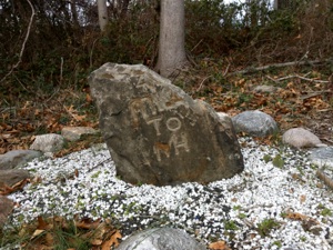
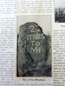
The rate of travel from Boston to New York has changed dramatically in the past four centuries. I am sure the reader will be stunned by this information, but this is an appropriate moment to spend a little time looking at the actual data and comparing both modes of travel and rates of travel from the settlement of New England by Europeans in the seventeenth century to the present day. As the first couple of miles in Fairfield, Connecticut are fairly dull, and I find myself passing a couple of shopping malls along US1, then under Interstate 95, and once more across the railroad tracks in the space of two miles, with nary a site of interest in view, my thoughts turn to the time it takes for people to travel from one point to another. I follow the road once again called King’s Highway in Fairfield (but still US1) southwest for a mile through a large rotary at Interstate 95, where I leave US1 when it becomes the King’s Highway Cutoff, and continue behind the office park and the Best Western on King’s Highway until I reach the railroad tracks, where a new station is being constructed in East Fairfield. This forlorn and uninteresting area is redeemed by the appearance of a milestone marking the distance to New Haven at the northwest corner of Vermont Avenue and King’s Highway. The top of the stone has has broken off, but I find a photograph of the stone from the 1930s which indicates it is the 22 mile stone from New Haven, which is what I would expect to find in this area based on the Colles map from 1789 that I have been using. Somebody has lovingly set this stone in a small clearing by the side of the road and has even done a little gardening around it to make it more comfortable amidst the bramble and construction debris nearby. Henry Sage, in his essay on milestones in Connecticut, writes of a mile 21 stone and a mile 23 stone, neither of which I am able to find, but does NOT mention this stone, leading me to believe that somebody rediscovered it subsequently. Whatever its history, I am happy to have my thoughts of travel times interrupted by the milestone. Incidentally, Sage says of the stretch where the “21 Miles to New Haven” stone was located that it is “on a road now but little used and still bearing the official name of “King’s Highway.”(1) Today this is a very busy stretch of Route 1 where the Tunxis Hill Shopping Center is located. US1 was rerouted from what is today Route 130 (see below) along this “little used” stretch sometime in the interim between Sage’s description (1951) and today.
I continue over the railroad tracks via a short detour on Grasmere Avenue before reconnecting with the King’s Highway, which I follow behind a second shopping mall, until I reach the junction with Post Road (US1 again) and Route 130, which is what Post Road becomes when it crosses King’s Highway until it reaches the Bridgeport line, when it becomes Fairfield Avenue. I cross Post Road and King’s Highway changes name again, this time to Old Post Road. Colles’s map of 1789 indicates that what is today Route 130 was “another way to Stratford,” and he places the 64 miles to New York marker near the junction, but I find no evidence of a milestone. I cross a small creek where I spot a half dozen Hooded Mergansers in full beautiful plumage and spot a Cooper’s Hawk sitting in a nearby tree (mergansers are too big for a Cooper’s, which probably explains their indifference).
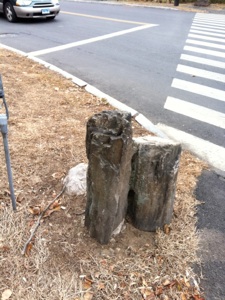
Old Post Road now becomes very pleasant as I enter the older and wealthier area of Fairfield. As Old Post Road curves I notice a small stone placed by the side of the road. This is one of many I notice in the next few miles, and they always appear when the road does something unusual such as taking a sharp turn or if two roads diverge. I believe they are way markers placed to assist travelers in finding the old road. The remainder of the walk into the center of Fairfield is very enjoyable as I pass beautiful houses along a wide and quiet road. I walk the final half mile to the old center of Fairfield and reach the Fairfield Museum and History Center where I spend some very productive hours in the research library. I will save the interesting parts of Fairfield for the next entry and devote the remainder of this entry to following the thoughts I had about travel along this route over time.
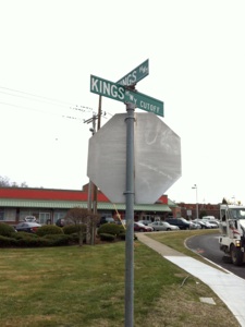
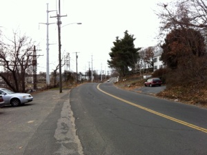
The road to Fairfield center. Top left: Intersection of King’s Highway and King’s Highway Cutoff in Fairfield. Notice the exciting scenery in the background, not atypical of this stretch of the walk. Top right: Old King’s Highway, here a quiet but somewhat forlorn stretch that runs adjacent to the railroad tracks for a while. In the distance to the right I discover an old milestone, middle left. This lovingly cared for stone once said “22 miles to New Haven,” as the photo at bottom left from the 1930s illustrates, but a chunk of the stone has been lost. Middle right is another interesting junction, this time the intersection of Post Road (US1 here) and Old Post Road, which is the name King’s Highway takes as it crosses Post Road. In the background can be seen the modern roadside tavern, McDonald’s. Bottom right is a stone at the intersection of South Benson Road and Old Post Road. There are a number of these curious stones set by the side of the road, often at places where the traveler might be confused as to the direction of the road. Are they way markers? If so, who put them there and when?
The first thing the mathematically inclined reader will observe is that a graph of the time taken to reach New York from Boston plotted over the years since New England was settled in the 1620s will be asymptotic. This should be readily apparent owing to the fact that it will never be mathematically possible to travel from one point to another without taking any time at all, even accounting for relativity. That said, the minimum time it takes, even on an airplane, to reach New York from Boston today is certainly not less than three hours. An airplane will not bring the traveler directly to lower Manhattan; to accomplish this, even a very wealthy individual would still require at least a helicopter ride and, if anything, the time required at security lines, and going to and from the airport negate most of the advantages provided by the relative speed of a jet compared to a car or train.
My rate of progress on the other hand is by far the slowest of all the possible modes of transportation and, even by historical standards, about as slow as it can get, as readers will have deduced by now if they have been following my journey. But then I am in no hurry to reach my destination. In fact the journey IS the interesting part for me. The destination is somewhat arbitrary albeit a convenient and important stopping point. I could have continued along the entire length of the old post road in America to Charleston, South Carolina, but decided to pursue the section of most historical interest to me. Perhaps a future trip will allow me to amble through New Jersey, Pennsylvania, Delaware, Maryland and other states beyond New York.
Totaling up the actual amount of time I have walked along the road is difficult to do, but my best estimate is that I have spent about 26 days on the road over the course of this project. This does not include multiple trips on some segments but does try to factor in the actual amount of time I have spent in the various towns through which I have traveled. This averages out to a little over 10 miles per day. At that pace I will need somewhere on the order of six or seven full days to reach New York, but since New York is what it is I will be sure to take my time as I make my way south through the Bronx and Manhattan once I reach the city limits. Certainly the weather is not conducive to long saunters through the Connecticut coastal towns, but a future entry will look at the topic of winter travel in colonial New England so a walk in a corresponding cold and wintry landscape will set the tone for that entry.
*****
Above is a series of maps illustrating the changing rate of travel from New York over the course of 130 years. According to the first map the time it took to travel from New York to Boston in 1800 was between four and five days. By 1850 almost all of New England could be reached within a day’s travel from New York. By 1930 a traveler could reach Los Angeles by train in three days and by plane within 36 hours. Reproduced from the Atlas of the Historical Geography of the United States. Today three to three and a half hours is the fastest possible trip time between the two cities. My rate of travel is a little bit slower.
Having set the parameters of the possible length of a contemporary trip from Boston to New York (three hours at the fastest, a little more than a month at the slowest, a record unlikely to be challenged anytime soon), l would like to take a look at some actual trips taken by travelers over this track since records of travels began to be kept. But first I want to establish a theoretical time the trip would have taken in pre-colonial New England. For this purpose I propose that a native of the Shawmut peninsula in Boston had reason to visit the Lenape Indians who inhabited Manhattan in the sixteenth century (or the sixth century for that matter as Braudel helpfully reminds us). As there were no pack animals, he (or she) would be obliged to walk. Humans walk at about an average of three miles an hour, and the distance he would have to travel would not have been appreciably different from the distance listed in Tulley’s Almanac of 1698 as these routes essentially followed the Indian paths that existed when the English showed up in the early seventeenth century, a distance of about 280 miles. This works out to about 93 hours of walking. If our hypothetical Massachusetts native is alone and unencumbered by much baggage he would probably have been able to walk at least 20 miles per day. Winthrop covered the distance from Old Saybrook to Providence, a distance of 90 miles, on foot in winter in 8 days, a rate of 11 miles per day, but he was visiting people and was hindered by the weather, so being generous and assuming that the hypothetical traveler was purposefully traveling directly to New York via the coast and met with good weather, he could average twenty miles a day.(2) I should also add that on at least two days of this trip I traveled in excess of twenty miles and found it to be not too difficult a proposition. I propose that a reasonable amount of time to accomplish this hypothetical trip would be two weeks, give or take a day or two.
Knight traveled from Boston to New York in 1704 by horse and was not sightseeing or in any other way distracted from her mission to reach New Haven. She left Boston at 3 p.m. on October 2, 1704, reached North Attleborough on the first night, North Kingstown, Rhode Island on the second night, and made it to New London on the third night, where she stayed two nights. Resuming on October 6, Knight reached Killingsworth (Clinton) that evening, and reached New Haven at two in the afternoon on Saturday, October 7, 1704. The total time Knight spent traveling from Boston to New Haven was the better part of five days.
Resuming her trip to New York on December 6, 1704, Knight reached Fairfield, where I am at the moment in this project, by nightfall. On the second day Knight reached Rye, New York, and she reached New York City “about an how’r before sunsett” on December 8, 1704. (3) Thus Knight traveled for the better part of eight days to reach New York from Boston. Knight’s return trip was slower as a result of being unable to travel on the Sabbath and bad weather, but the total trip time from New York to Boston was again about eight days.
Dr. Alexander Hamilton was visiting New England for health reasons and was not in any particular hurry, but calculating the time he took to travel is still informative as he generally did not stop to smell the roses along the way either. He left Boston at nine in the morning on August 17, 1744, forty years after Knight’s journey, and reached Newport on the evening of the next day. He spent some time in Newport before departing August 24, crossing the Jamestown ferry and proceeding through southern Rhode Island and Connecticut to reach New York at noon on August 31, one week later. Thus Hamilton managed the trip in ten days, slightly longer than Knight.(4)
Birket left Boston on September 18, 1750 and reached Newport the following evening. From Newport Birket departed in the same direction as Hamilton on October 3, 1750 and reached New London on the evening of October 5th, where he remained for two days. On October 8th Birket departed for New Haven, which he reached the next day and stayed only the night. On October 10th Birket left New Haven and reached his lodgings in Manhattan on October 12th, 1750, for a grand total of ten days travel. (5)
Napoleon’s rise to power in France occurred just after Washington’s death in 1799 so we can presume that Braudel and Valéry would include Washington’s 1789 journey through New England in the purview of their sweeping conclusion about transport in the preindustrial world. Washington departed New York on Thursday October 15th, 1789 at nine in the morning and reached New Haven at 2 p.m. on Saturday October 17th. From New Haven, Washington was obliged to travel around Rhode Island, which was not formally under his jurisdiction at the time owing to the fact that the state legislature had yet to approve the Constitution, so he took a different route from the previous travelers heading through Hartford and across Massachusetts (the “upper Post Road”). He departed from New Haven on Monday, October 19th at 6 a.m. and reached Boston on Saturday October 24th after being feted and waylaid by adoring citizens along the entire route. Washington’s trip took the better part of nine days. (6)
*****
An ad in the New York Journal from June 25, 1772 promotes the new stagecoach line from New York to Boston, which traveled once per fortnight leaving on Monday and reaching Boston on Saturday evening, from whence it departed to return to New York, arriving on the following Saturday and repeating the cycle again the following Monday. (7) Thus the advertised journey length works out to six days of very hard traveling. No wonder the citizens of the newly formed United States were such enthusiastic builders of turnpikes and canals. The post riders, who split the route up into sections to speed delivery, normally took six days in the summer and up to nine days to complete the journey if conditions were unfavorable, and it can be assumed that, like today’s scheduled trips, many if not most of the stagecoach trips failed to arrive on time. This works out to about forty miles a day for horse and rider, requiring at least a pace of four miles an hour and factoring in food breaks and rest stops.
Many travelers made the trip to New York by sea if possible, which was substantially faster as long as the winds were favorable. The phrase “the winds of fortune” did not however materialize from thin air as it were, and so a good deal of luck was required for a sea voyage to be much faster than the stagecoach.
Turnpikes helped a little, but it was the railroad that was the catalyst for the increased pace of modern life. As Tony Judt wrote so eloquently in one of his posthumously published essays in a recent issue of the New York Review of Books:
More than any other technical design or social institution, the railway stands for modernity. No competing form of transport, no subsequent technological innovation, no other industry has wrought or facilitated change on the scale that has been brought about by the invention and adoption of the railway. Peter Laslett once referred to “the world we have lost”—the unimaginably different character of things as they once were. Try to think of a world before the railway and the meaning of distance and the impediment it imposed when the time it took to travel from, for example, Paris to Rome—and the means employed to do so—had changed little for two millennia. Think of the limits placed on economic activity and human life chances by the impossibility of moving food, goods, and people in large numbers or at any speed in excess of ten miles per hour; of the enduringly local nature of all knowledge, whether cultural, social, or political, and the consequences of such compartmentalization. (8)
The coming of the railroad marked the beginning of the accelerated pace of life that continues today. Thoreau detested the railroad for speeding up the pace of life, but he was in the minority. The early rail trip from Boston to New York was often a hybrid of rail from Boston to Providence, steamer from Providence to Long Island, and rail on Long Island into New York, or by steamship all the way to New York from Providence. It was impossible to reach New York along the route of the Post Road solely by train until 1889 when a bridge was built across the Thames River. Prior to that time the passengers either were ferried across the river to resume their journey in New London by train or took a ferry from New London to Long island (as some do today) or New York. I found a proposal from 1832 for the construction of the railroad from New York to Boston via Providence which gives the following data regarding the rate of travel at the time :
It must be evident to those acquainted with the character of the country, that this route will continue for a long term of time to be the principal medium of communication between Boston and New York, as no road will ever be made to the eastward of this, and the almost impassable hills with their 600 or 800 feet elevation, and the nature of the ground, entirely precludes the idea of a more western route. The time at present required for a passage from New York to Providence, is from 16 to 18 hours, making 24 hours or more to Boston; when this line of railroad shall be completed from Boston to Stonington, passengers can then be transported from New York to Stonington in 8 to 9 hours, thence on the Railroad to Providence and Boston in 4 or 5 hours more, making 13 or 14 hours, and can therefore go by daylight most of the year, and avoid the very unpleasant, not to say dangerous, passage round Point Judith. (9)
*****
Today the Acela Express train makes the journey in three and a half hours, which is slightly faster than the bus, which advertises a time of four hours and twenty minutes non-stop from Boston South Station to The Port Authority in New York. A car traveling at 65 miles per hour can make the trip in a little under four hours if there is no traffic, and the plane takes roughly the same time as the Acela train but it involves much more of a hassle, perhaps explaining the increasing popularity of the latter option. Braudel and company were right to note that modernity can be measured by the speed at which people moved from one place to another: the rate of change in travel time in the last two hundred years compared to the previous two millennia is staggering.
I am happy to have walked a mere three miles thus far today. From a tedious start at the Bridgeport line through the modern travel network of the Northeast Corridor I have reached a lovely and historic stretch of road that allows me to retreat to the eighteenth century once more. All I have to show for my effort this past hour are a hawk, some ducks, and a rock with an inscription on it. Not a bad haul for such an inauspicious stretch of road. The next few miles promise even more “exotic” rewards. Time to slow down.
Thursday, January 13, 2011

Walking the Post Road
Junction of Post Road and Old Post Road in Fairfield. The three mile stretch that includes this area is not particularly scenic, mostly views of Interstate 95, train tracks, and exotic establishments such as McDonald’s, Walgreens, and Bed, Bath, and Beyond. Lots of time to daydream.
“Napoleon moved no faster than Julius Caeser.”
Paul Valéry, cited in Fernand Braudel, The Structure of Everyday Life, (Los Angeles, California: UCLA Press, 1992), 429.
Distance Walked in the Entry: 3.06 miles
Total Distance Walked in Connecticut: 112.33 miles
Total Distance Walked for this Project (from Boston): 282.9 miles
Distance Remaining to New York: 63.5 miles
Notes
-
1. Henry P. Sage, The Milestones of Connecticut, 45.
-
2. John Winthrop Jr., Travel Diary, (1645), 504-508.
-
3. Sarah Knight, Diary of Madam Knight, 67-75.
-
4. Alexander Hamilton, Itinerarium, 146-72.
-
5. James Birket, Some Cursory Remarks, 25-40.
-
6.George Washington, Diary, 19-33.
-
7.Frederic Wood, The Turnpikes of New England, 27.
-
8.Tony Judt, The Glory of the Rails, New York Review of Books, December 23, 2010. http://www.nybooks.com/articles/archives/2010/dec/23/glory-rails/
-
9.William Gibbs McNeil, Captain U.S.T. Engineers, Report on the Survey for a Rail Road from Stonington, Conn. to Providence, R.I. with an approximate estimate of its cost, March 1832. Accessed from Google Books January 12, 2010. Here is a biographical summary of this interesting man.
-
10. 1930s Milestone image from the collection of the Fairfield Museum and History Center, thanks to the generous assistance of Assistant Librarian/ Genealogist Rod MacKenzie.

