Entry #8: Mile 4, Jamaica Plain. Traveling the World.

Traveling the World
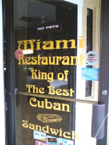
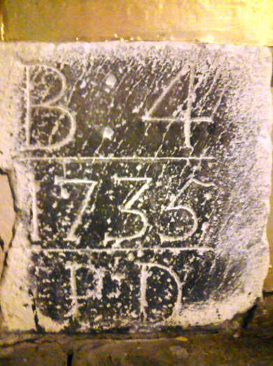
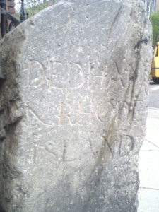
“...Y un batido, por favor.” “Hay guanabana, mamey, fresa, mango, pina, tamarindo...” “De guanabana.” I take my fruit shake and sit down in a booth in the Miami Restaurant, with my pressed pork sandwich, called a cubano. The combination is delicious and ridiculously high in calories and sodium, but I don’t eat one every day so I happily gorge myself for less than eight dollars. The place calls itself the ‘King of The Best Cuban sandwich,’ and the sandwich is as good as ones I have eaten in Miami (the closest I have been to Cuba and center of the largest Cuban community outside Havana). The Salvadoran place across the way, ‘Pupusa La Guanaca’, is a very good place as well, especially their cheesy and bean filled tortillas called ‘pupusas’ which are filling, tasty, delicious, and cheap. There are other Cuban places nearby, including the famous ‘El Oriental,’ as well as a couple of Mexican restaurants, and Dominican and Puerto Rican storefront bakeries, fruit shops, and fast food joints. Across the street from where I sit, in the wall of a ‘jewelery’(sic) store, is the milestone placed by Paul Dudley in 1735 indicating that Boston is four miles away. In less than one mile I have followed the Post Road from the Congregationalists of eighteenth-century Roxbury to Latin America, the ‘Latin Quarter,’ Hyde Square in Jamaica Plain.
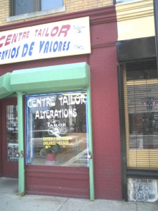
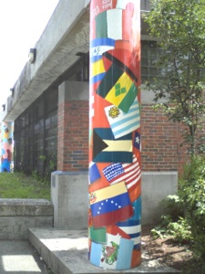
Above Left: Miami Restaurant entrance, Hyde Square. Above Right: One of the many businesses catering to the Spanish-speaking community. Notice the milestone in the bottom right corner of the photograph, at 368 Centre Street, Jamaica Plain.
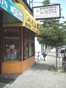
The area from Jackson Square to Hyde Square on Centre Street in Jamaica Plain is the center of the Hispanic community in Boston. Stores advertising their wares in Spanish line the street for half a mile, almost all of the conversations are in Spanish, and on a hot day in Mozart Park, it is very difficult to distinguish the scene from that of any plaza in Mexico or Costa Rica: the man selling flavored ice from a cart, the empanada bakery, posters advertising concerts plastered on the windows of Franklin’s CDs --judging by the photos on the wall behind the counter a haunt of Pedro Martinez, Big Papi, and Manny Ramirez, among other Latin baseball players who have played for the Boston Red Sox--, the driving Reggaeton beat emanating from the speakers of the passing cars lovingly detailed in chrome, the storefront Pentecostal churches, and the ubiquitous ‘Envios de Valores’ signs, where people working in Boston can send remittances to loved ones back in Santo Domingo or Managua.
Above Left: A celebratory sign. Above Right: Sidewalk view of Centre Street in Hyde Square
*****
The forty-five million people who speak Spanish as a first or second language according to the Census Bureau (which does not include millions of undocumented workers) will not be surprised to find a scene like this in any major city in the United States. A little discussed fact is that the United States has the second largest Spanish speaking population in the world after only Mexico and in front of Spain, Colombia, Argentina, and Peru (1). I find it amusing when in a restaurant in Mexico or Spain to be the person doing the translating at a table with French, German, or English acquaintances. After all, I have been informed countless times over the years when traveling that Americans never speak foreign languages. Coupling the above data with the observation that millions of people of Chinese descent live in the United States as do millions of immigrant families from all over the world, it seems that Europeans need to rethink their outdated images of Americans as monolingual. When the citizens of a country like Sweden, with the population of North Carolina, boast about speaking English, I have to point out that only nine million people speak Swedish and in order to function in the world, learning another language is a matter of survival. We have the luxury here of speaking the most important language in the world. In fact the United States is in the unique position of having the most English speakers in the world, the second largest Spanish speaking population in the world, and the largest Chinese speaking population (estimated at 2 million, including both Mandarin and Cantonese) outside a majority Chinese country such as China, Taiwan, and Singapore. These are the three most widely spoken languages in the world. Hyde Square is America. (2)
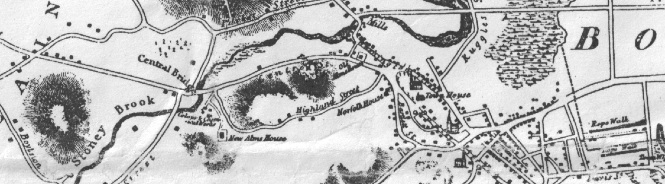
Above: Map of Roxbury and the Stony Brook by John G. Hales, 1832. The First Church of Roxbury is visible to the right of the map above the Town House. The new streets built across the Back Bay, such as Tremont Street are visible to the north of the church. Centre Street curves left away from the church down to the Stony Brook at Central Bridge. (The name of Hog Bridge over the Stony Brook by 1832), and Hyde Square is the intersection of Centre Street leading left away from Central Bridge and what is Perkins Street at the left edge of the map. Central Bridge today would be roughly where Jackson Square MBTA station is located.
*****
I came here to Hyde Square from Eliot Square in Roxbury. I strolled downhill on Centre Street away from the milestone indicating three miles to Boston and arrived at a large, busy street where once the Stony Brook ran into the Fenway. The Stony Brook still runs, only it has run in underground pipes since the middle of the nineteenth century. Now only traffic runs through the Stony Brook Valley in myriad forms: walkers and bikers on the Southwest Corridor Park paths; cars, buses and trucks on Columbus Avenue; the MBTA Orange Line, the Commuter Rail, and Amtrak. The Stony Brook Valley has for over a century and a half, been a major transportation corridor into the City of Boston. In 1832 Tremont Street was extended straight out from Boston through the marshes of the Back Bay and intersected the old road to Cambridge at Roxbury Crossing (named for the place where the road to Cambridge crossed the Stony Brook). The Tremont Street route became the more direct route out of the city and bypassed the Post Road completely. A report by Francis Jackson, Land Commissioner of Boston, published in the Boston Central in December 1832 gives the following information: “ From the Parsonage of the 1st Church Brookline to the Old State House, Boston: Over the neck-5 miles 0 quarters 37 rods. Over the Western Avenue (Mill Dam) [Now Brookline Avenue and Beacon Street]-4 miles 1 quarter 77 Rods. Over the Tremont Street into town- 4 miles 2 Quarters 56 Rods.” After 200 years as the sole land route out of Boston, the twisting road down the Neck, through Roxbury and into the hinterlands had been superseded.
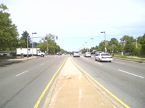
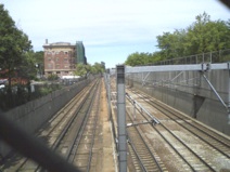
More traffic was to come with the opening of the Boston to Providence Railroad in 1834, the tracks being routed straight down the Stony Brook Valley out to Forest Hills and beyond. Rail had arrived and continues to this day. As I stand at Columbus Avenue, which is the main four lane thoroughfare through which traffic pours out of town into the neighborhoods, I watch the high-speed Acela train rocket along the sunken tracks adjacent to the street on its way to New York in three and a half hours, a far cry from the 10 days it took in the 17th century. Commuter Rail trains as well as the MBTA run down the tracks below and the Jackson Square MBTA station behind me is a major bus interchange. Along with the bustling traffic at the corner of Centre Street and Columbus Avenue, this is one of the noisiest places I have encountered thus far on my brief journey. At least there is not a major interstate highway roaring through as well, and therein lies a tale of civic action.
Above: Southwest Corridor multi-modal transportation corridor, formerly where the Stony Brook ran and nearly Interstate 95. Left: Trains, Orange Line MBTA, MBTA Commuter Rail, and Amtrak. Center: Bike path and sidewalk. Right Columbus Avenue, four lanes of traffic at ground level. Photographs taken at site of Central or Hog Bridge over the Stony Brook.
*****
In the late 1940s, transportation planners envisioned a system of interconnecting controlled access highways that would be fluid and free of impediments such as traffic lights. These ‘Interstate Highways’ would increase commerce by speeding up delivery of goods between urban areas as well as between rural and urban areas. They were designed to facilitate troop and supply transport in the event of war. (3) They would also allow people living in crowded congested dirty cities to move out to the fresh air of the newly developing suburbs. Many of these highways were constructed beginning in the 1950s with little regard for the urban areas through which they passed. Until it was recently moved underground, a major elevated highway, Interstate 93, ran directly through the city of Boston, effectively cutting the city off from the harbor which had defined it for three centuries. This route was constructed by seizing hundreds of properties and cutting neighborhoods such as Dorchester into two pieces.
A similar plan was designed to bring Interstate 95 directly into the city through Hyde Park and Jamaica Plain along the Stony Brook corridor where I stand. Land was seized, many buildings were razed and a large vacant wasteland materialized where once the Stony Brook ran. However the effects on Dorchester of the I-93 project were plain to see and a public uproar ensued. The project was killed by the Republican Governor of Massachusetts, Francis Sargent, in 1970.(4) Sargent was widely praised for his enlightened approach to conservation and advocacy of a multi-modal urban transportation system. (I will leave it to the reader to marvel at the idea of an enlightened Republican. Times have changed).
The empty land intended to accommodate an Interstate Highway was transformed into a multi-modal transportation corridor, still known as the Southwest Corridor. The Orange Line of the MBTA was rerouted from Washington Street and depressed (thus removing the elevated railroad that blighted the first two miles of the Post Road. See entry #4). The train lines for the Commuter Rail and Amtrak were also depressed. A bike path was constructed alongside Columbus Avenue, providing direct access to the Back Bay. Numerous playgrounds and park lands line the railroad tracks from Back Bay to Forest Hills. The Stony Brook continues to be a major transportation corridor, but compared to an elevated multilane highway that would have divided this area of Boston and depressed real estate values, the current incarnation has been much more successful in preserving the neighborhood. I never would have moved to Jamaica Plain had an interstate highway existed one hundred yards from my house.
*****
The Stony brook was crossed here in the 18th century via what was called the Hog Bridge. On the opposite side of the brook was the large estate of William Heath, a major general in the Continental Army. Today the land is occupied by the large Bromley-Heath housing project, first planned in 1939, one of the oldest such developments in Boston. The Bromley-Heath has an unfortunate reputation for crime and violence. As I walk on the short stretch of Southwest Corridor from Columbus Avenue to Centre Street in Jamaica Plain I pass a basketball court which is covered with flowers, stuffed animals, candles, and notes of remembrance. Only last week a fourteen year-old boy, Jaewon Martin, was shot to death as he and a friend talked with some girls here on the basketball court.(5) I have biked and walked through this area for thirteen years and have never had a single problem, but for the young teens who live and play in the area, the situation is often much more dangerous. The senseless slaughter of inner city youth in Boston and other urban centers needs to be brought under control, but solutions are proffered, and time and again the same scene in front of me is repeated. An almost identical story ran in 2007 when thirteen year-old Luis Gerena was killed in the same area.(6)
*****
The owner of Miami Restaurant, Juan Reyes, tells me he is “selling next year because the neighborhood is going down.” Of course he told me the same thing three years ago when I last spoke with him. The neighborhood around Hyde Square, up the hill from Jackson Square and Bromley-Heath seems more vibrant than ever, with more restaurants and even an influx of twenty-something art students and musicians patronizing the new cafes and the tattoo parlor, Fat Ram’s. If anything the neighborhood has become more expensive, and I wonder how long the Hispanic community can remain as the rents rise higher and higher. For the Hyde Square area is the frontier of the two Jamaica Plains, the other version being the one I inhabit: significantly wealthier, and populated by liberal, well-educated professionals. Wags refer to the two parts of “JP” as “Gay P” and “Jamaica Spain,” and there is a kernel of truth in these vulgar terms. The border here is fluid; some streets are filled with smart, restored Victorians inhabited by lawyers and authors; the next street is filled with triple-deckers covered with vinyl siding. People of different classes, languages, sexual orientation, and race co-exist well. But real estate pressure is changing the dynamic. Rather than worry about the future, I will just eat my cubano, drink my batido, and enjoy it while I can.
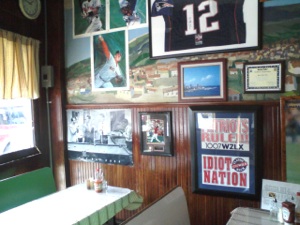
Above Left: Interior of Miami Restaurant. Above Right: ‘Flagpole’ Jackson Square
*****
Census figures for the area through which the road travels provide some data to support my observations. The Hyde Square area is located in Ward 10, Precinct 9, which stretches for some distance over into “my Jamaica Plain,” but nonetheless has a population comprised of 35% Hispanic residents. My estimate for the Hispanic population of the area immediately adjacent to Centre Street from Hyde Square down the hill to Jackson Square is about 80-90%. The total population of the area from Hyde Square to Jackson Square, which comprises Ward 10, Precincts 6,7, and 9, is 9828 (data is from the 2000 Census), of which 21% is White, 25% is Black (largely in the Bromley Heath area), 48% is Hispanic, and 4% is Asian. As one passes Hyde Square, Centre Street veers left and continues as the main street of Jamaica Plain. The area from Hyde Square to the stone marking five miles to Boston is comprised of Ward 19, Precincts 1,3,4,5,6,8, and 9. This area has a population of 10,474 of which 74% is White, 8% is Black, 12% is Hispanic, and 3% is Asian.
In the span of four miles we have passed through a diverse sampling of the American population. At the site of the first milestone, located in Ward 3, Precinct 8, the predominant ethnic group was Chinese, and 58.8% of the population was of Asian descent. The second milestone would have been found in Ward 9, precinct 3, in the South End, which is predominantly African American (47.4%) and becomes increasingly so as we pass through Dudley Square in Roxbury. The third milestone, on Centre Street just past Eliot Square, is still in Roxbury, but it is a mixed neighborhood containing some large older houses as well some affordable housing. This area is in Ward 11, Precinct 1 which is 55.6% African American, and 21.9% White. Milestone four in Hyde Square is in an area that is 48% Hispanic overall, but has a much higher Hispanic population in the immediate area of the milestone. The fifth milestone is in Jamaica Plain at Monument Square, (in my neighborhood. See entry #1 and the next entry in the series (#9) for more), Ward 19, Precinct 8, which is 86.2% White.
As we head away from the heart of the city we will remain primarily in areas with less ethnic and racial diversity than we have encountered thus far until we reach the next major city on the road, Providence, Rhode Island. The theme of many of these future entries will be about the natural world, history, and politics but whenever any evidence of the amazing diversity of the country in which I live presents itself, I will not hesitate to discuss it. Not only can I travel in time on the Post Road, I can also travel the world. At the very least I will likely get some good meals out of my explorations.
Tuesday, May 18, 2010
Walking the Post Road
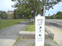
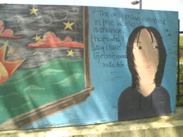
Left: Milestone, Hyde Square, Jamaica Plain, MA. Above Right: mural at Bromley-Heath housing development.
2. I will also add that I have been told many times in my travels that Americans don’t play soccer either. Tell that to the eighteen plus million people who can be found kicking a round ball around a field somewhere in the United States on any given Sunday. That is larger than the entire nation of the Netherlands, although I admit the Dutch are pretty good. I predict that the USA will defeat England on June 12, 2010 in Rustenberg South Africa, finally laying to rest the old canard.
6. http://www.boston.com/news/local/articles/2007/01/14/no_arrests_in_slaying_of_13_year_old/