Entry #64: Mile 270, New York. Diversions along the Bowery.

Manhattan below Madison Square was the virtual edge of New York City in 1836, as the map below shows. Although the grid plan had been adopted and some streets above Madison Square had even been built, the population only slowly followed. In 1840, four years after the map below was published, the Census counted 312,710 residents of New York. Of these, only about 11,000 lived north of 26th Street. Twenty years later over 230,000 New Yorkers (of 805,000) called home somewhere above Madison Square, and the numbers continued to accelerate. Today more than two thirds of Manhattan’s 1,630,000 residents lives in the areas north of what is often called Lower Manhattan (although the definition seems to change depending on who is defining the area: some argue it is the area below 23rd Street, some say it is below 14th Street, others the area below Houston Street, and still others [the purists] argue that Chambers Street marks the northern limit of Lower Manhattan). Of the areas below Madison Square (roughly below about 26th Street), the area north of 14th Street (Chelsea, the Flatiron District, Union Square, Gramercy Park, etc.) has a population of a little over 100,000, while Greenwich Village and the East Village (Houston to 14th Street) have close to 150,000 residents. The area below Houston Street, essentially the northern limit of New York City before 1800, today has about 170,000 people. Thus, although more and more people choose to live in Lower Manhattan, the roughly 400,000 residents today do not equal the more than half a million who populated the lower reaches of Manhattan Island in the years before the Civil War. Indeed, a small portion of that territory, the area broadly defined as the Lower East Side, east of the old Post Road (Fourth Avenue and the Bowery) and below 14th Street, in the early 1900s had well over half a million people crammed into under 1.5 square miles, and a population density of close to 400,000 per square mile.
Despite the fact that New York County is the most densely populated county in the United States, with over 70,000 people per square mile, it used to be much higher. In 1910, there were over 2.3 million people on the island, over 101,000 per square mile; Manhattan has lost more people in a century than are to be found in all but about ten cities in the United States. Despite the dramatic loss of population, the difference between New York and the rest of the country is staggering even today; if New York City were a state of its own, it would have over 8 million people in a mere 305 square miles (one third the size of Rhode Island), which would place it 12th in the nation in terms of population and larger than the 9 smallest states (by population) put together! Cue rant about how unfair the Senate is, where the bottom nine states together have 18 Senators while New York City has to share 2 Senators with the remaining 11 million people of the state of New York.
More fun New York City facts: for most of the twentieth century, more than one in twenty people in America resided in New York City (not the suburbs, just the city). Even today about one in sixteen people in the United States is a resident of the New York metropolitan area. Depending upon who is doing the enumeration and what is included in the definition of the city, New York is anywhere from the second to the seventh largest city in the world. If you tried to put everybody in the United States into an area such that the population density of the entire nation was equivalent to that of Manhattan, you could fit everybody in the country into Connecticut with 10% of the state left over. And finally, the gross metropolitan product of New York is over $1.1 trillion, which would rank New York in the top 15 largest countries in the world in terms of largest economies and second behind only California in the list of states by gross state product. I could go on and on, but I think it is time to keep walking.
*****
Madison Square is the remnant of a planned ‘Parade’ in the original Commissioner’s Plan of 1811, which was to extend from 23rd to 34th Street and from Third to Seventh Avenues. (1) In the first decade of the nineteenth century a military outpost was established here, at the junction of the two major arteries which headed into New York City from the northern reaches of Manhattan Island: the ‘Eastern’ Post Road (the road I have been following) and the Bloomingdale Road, which passed up the western side of the island to the area called Bloomingdale, today the West Side of Manhattan. Bloomingdale Road is today known as Broadway, while the ‘Eastern’ Post Road is gone, a victim of the grid plan. The area was still an isolated military outpost well into the nineteenth century, but by the middle of the century the northeast corner of Madison Square was the site of the Union Depot of the New York & Harlem Railroad. After the terminal was moved to 42nd Street, eventually becoming Grand Central Station, the land was taken over by P.T. Barnum (whom we met in Bridgeport, CT) who built what was called the Hippodrome on the site. A decade later it became the first Madison Square Garden.
In 1890 Stanford White built the second and much more extravagant Madison Square Garden on the site, which survived until 1925 (twenty years longer than the architect White, who was shot in the Roof Garden of the building he designed, a very famous story recapitulated in the book Ragtime, by E.L. Doctorow and the subsequent movie), when it was rebuilt at 50th Street and Eighth Avenue. In 1968 the current Madison Square Garden was built on Eighth Avenue between 31st and 33rd Streets ironically “on the site of McKim, Mead, and White’s greatest architectural achievement-Pennsylvania Station- which fell victim to the wrecker’s ball and civic short-sightedness.” (2) Thus, for those of you who are confused about why Madison Square is nowhere near the Garden, you now know the answer.
There are many other anecdotes about the buildings and the area that could easily fill this and other entries, but I need to get going--again I highly recommend The Bowery Boys website and podcast to those who might want to dig deeper into the history of New York. For the purposes of this project, I will try to stick to the history of the Post Road itself and try to give some sense of how the road and the areas through which it passes have changed over time. The salient points about Madison Square Park are: 1. It was the site of the three mile stone of the Post Road as shown on Christopher Colles’s 1792 map of the road; 2. It was the northern limit of settlement in New York as late as the 1840s and hence was the first place a visitor would begin to feel that he was entering New York; 3. The Post Road merged with what is today Broadway in Madison Square, and the road heads southeast for ten blocks as Broadway, before the two roads separate again at Union Square.
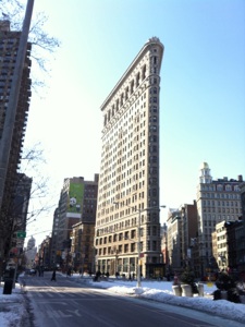
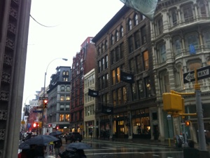
The entrance to the Post Road south of Madison Square is dominated by the classic skinny triangular form of one of the most famous buildings of New York, the Flatiron Building, whose triangular ‘prow’ jutting into Madison Square is a mere six feet wide. Broadway from 23rd Street to 8th Street had, by the 1870s, become the shopping center of New York, and the plethora of retail stores along what was once the Boston Road earned this stretch of the road the sobriquet “Ladies’ Mile.” For three decades, the major department stores of New York were located here, the most famous of which was Lord & Taylor, located on the southwest corner of 20th Street and Broadway from 1870 until 1914, when it moved to Fifth Avenue and 38th Street. (3) Today there are no more department stores as all of them migrated to points north in lockstep with the inexorable shift of the population. However the area has become newly fashionable as the ‘Flatiron District,’ and many of the interesting cast iron buildings from the late nineteenth century remain, albeit as smart boutiques, cafes, restaurants, and residential spaces today.
*****
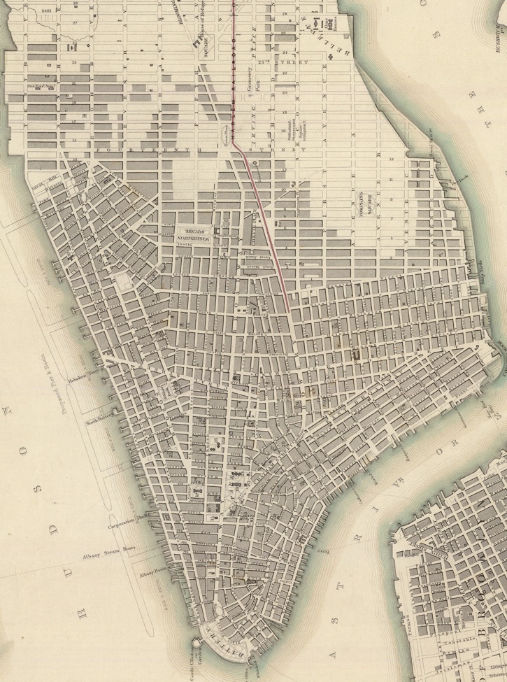
Above is a map of New York City published in the 1830s that shows the extent of development in New York City (the blocks shaded in grey). At the top center is Madison Square. Notice that the Post Road is still shown on the map heading northeast out of the square and that Broadway heads northwest (although it is called Bloomingdale Road). Also notice the red line of the newly built New York & Harlem Railroad, which had its depot at the northeast corner of Madison Square until 1871, eventually moving to become what is today Grand Central Station. From Union Square, the red line of the railroad followed the Post Road along what is today Fourth Avenue and the Bowery.
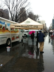
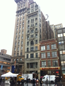
Below are images along the Post Road from Madison Square south. Clockwise from top left are 1. The Flatiron Building, an early and important skyscraper. 2. Broadway at 20th Street, site of Lord & Taylor’s, one of many retail stores along what was ‘Ladies Mile’ in the late nineteenth century. 3. Union Square Green Market, held even in the dead of winter! 4. Decker Building (center) in Union Square. The sixth floor was the site of Andy Warhol’s Factory from 1968 to 1973, and the place where Warhol and his manager were shot by Valerie Solanas in 1968.
In the pouring rain I arrive at Union Square, named not for ‘The Union,’ but rather as the intersection of Broadway and the Bowery (i.e the Old Post Road), or the ‘union’ of the two streets, which then headed north to Madison Square where they diverged once more as described above. Much to my surprise, there is a farmer’s market in full swing on a cold and wet day in February on the square. I pass the fine statues of Lincoln and Washington, both erected when Union Square was a fashionable residential area, and a statue of Mahatma Gandhi of more recent extraction. As I head south I continue to run into areas that were earlier and earlier incarnations, for some brief period, of the center of commerce or the trendy residential area of a bygone era. Union Square was first a prime residential district from about 1831 then, after the Civil War, it became a center of commerce, a place where Brentano’s and Tiffany’s once had their stores. At the southeast corner is what is now called Fourth Avenue but what was once part of the Bowery. Whatever its contemporary name it once served as the main road from New York to Boston. After a brief stop to get out of the rain at a great cafe called ‘Think’ between 12th and 13th Street, I continue onward south to the older and older parts of the city. This walk is like time traveling backwards; each block I walk brings me to a part of the city that once was the edge of town, then became the fashionable center, then was bypassed in favor of a more northern new favorite area.
For many people this area is the hip center of the city, as I straddle the dividing line between Greenwich Village and its formerly ‘edgier’ neighbor the East Village. Fourth Avenue, from 14th to about 10th Street, was once known as ‘Bookseller’s Row’ because of the large number of secondhand book shops located here, and the area was before that, like areas to the north, a fashionable residential area. In the late 1950s and early 1960s the area again became a fashionable place, this time for intellectuals, hippies, beatniks and other members of the counterculture. What was for over a century a working-class neighborhood that was still considered the northern part of the Lower East Side became the epicenter by the 1970s of ‘cool,’ attracting Charlie Parker, Jack Kerouac, the Velvet Underground and the Ramones among others. The hip center of New York has since moved to ‘cooler’ neighborhoods as gentrification and the encroachment of NYU pushed up rents, old buildings were bought and spruced up or torn down to be replaced by dormitories or luxury condominiums.
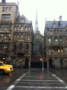
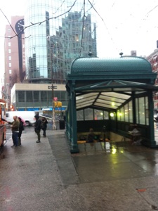
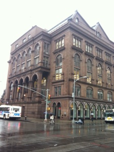
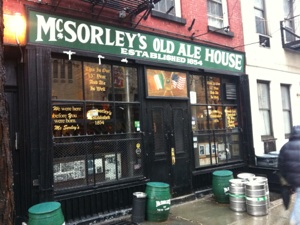
Each step in these neighborhoods seems to bring me to some elegant old building, or to an important historical or cultural landmark, or even to a place that has undergone so many different incarnations that it is interesting in its own right. On my right is the lovely Grace Church from 1846 facing Broadway at 10th Street, while the Gothic Revival Grace Church House and School face Fourth Avenue. Ahead of me is the lovely restored subway entrance of Astor Place Station, built on the site of the Astor Place Riots, a nativist riot met with brute force by the police resulting in over 30 dead and hundreds wounded, a riot which was started over arguments about rival performances of Macbeth by an English actor, William McCready and an American actor, Edwin Forrest, at nearby theaters. Directly ahead of me in Cooper Square is the Cooper Union Foundation Building, site of the famous speech in 1860 by Abraham Lincoln where he elaborated his views on slavery which established him as the rising star of the Republican party, and helped propel him to the presidency. On 7th Street is McSorley’s Old Ale House, a great old place redolent of ‘Olde New York,’ as evidenced by the famous slogan “We were here before you were born.” And so on...my head is spinning, and I have only walked a mile, and have not strayed from the path. This is the New York I love.
*****
New York--History at every step! Clockwise from top left: 1. View of Grace Church, one of New York’s landmark churches, taken from the rear of the church on Fourth Avenue. 2. Subway kiosk in Astor Place. 3. Cooper Union Building, the first building of the school and the site of Lincoln’s famous speech in 1860. 4. McSorley’s, not really from 1854, but still older than you.
In John Clapp’s Almanack of the Year 1697, the author gives a description of the road out of New York City as follows: “From the Post-Office in New York to John Clapp’s in the Bowery is two miles, which generally is the baiting place where Gentlemen take leave of their friends going so long a journey, and where a parting glass or two of generous wine ‘if well apply’d makes their dull horse’s feel, one spur i’ th’ head is worth two in the heel.’” Apart from the fact that the owner of Clapp’s Tavern is none other than the author of the Almanac, the salient piece of information here is that his tavern, which was located on the Bowery near what is today Cooper Square, is two miles out of town. Clapp later adds in his almanac, in case anyone needed to be reminded about his place, that “at the aforesaid Clapps, about two miles without the City of New York, at a place called the Bowr’y, any Gentleman Travellers that are Strangers to the City, may have very good Entertainment for themselves and Horses, where there is a Hackney Coach and good Saddle Horses to be hired.”
Colles marks the two mile stone on his 1792 map at a place corresponding today to roughly Fourth Avenue at Astor Place, a place where he also locates a tavern called Davenport’s, a testament to the longstanding importance of the area as a stopping place for “Gentleman Travellers,” a tradition maintained to this day at McSorley’s only a few yards away (a place which refused service to women until 1970). In the seventeenth century this was ‘without the City’ and even in the early nineteenth century the area north of Houston Street was essentially in the countryside, but in the 1820s nearby Lafayette Street became a prime residential area, with many newly wealthy merchants moving into houses along Colonnade Row on Lafayette Street, including John Jacob Astor, Cornelius Vanderbilt, and Warren Delano (Franklin Delano Roosevelt’s grandfather). In recent years the loft spaces of the neighborhood west of the Bowery, lately termed NoHo (North of Houston), have become prime real estate and made the area a well-to-do residential neighborhood again after a long history as a commercial center.
Although the streets technically are still numbered south to Houston Street, many have long had proper names as well, and the often lyrical and seemingly whimsical names are a welcome change from the miles of meaningless numerical streets and avenues. St. Mark’s Place (8th Street), Great Jones Street (3rd Street), Bond Street (2nd Street) and Bleeker Street (1st Street, where, nearby at 315 the Bowery, was the renowned CBGB, the center of the punk and New Wave scene, on whose stage many musicians, including the Ramones, Blondie, Patti Smith, and Talking Heads performed on their rise to fame) pass in quick succession as I continue down the Bowery which, like the Bronx, curiously possesses the definite article in its name. The Bowery is another word that has come to have a meaning greater than the street, in this case a byword for destitute poverty, a synonym for ‘Skid Row.’ The name derives from the Dutch word bouwerij, meaning farmland, which is what the area here was for many decades. The road itself predates the Dutch and was originally a footpath created by the Lenape Indians who lived here when Europeans first arrived in the early seventeenth century. (Incidentally, this website has amazing images of what Manhattan Island and the surrounding area might have looked like when the first visitors arrived on its shores from across the Atlantic.) That it was out of the city in 1704 is evident from Sarah Knight’s description of the habits of New Yorkers: “Their Diversions in the Winter is riding sleys about three or four Miles out of Town, where they have houses of entertainment at a place called the Bowery.” (4) Alas, the houses of entertainment along the Bowery had become distinctly disreputable by the Civil War, as the street marked the eastern border of the notorious Five Points neighborhood, a very poor and rough area notorious for the famous “Gangs of New York,” the most famous of which were the Bowery Boys, who were affiliated with the “Know-Nothing” nativist movement of mid-nineteenth century America. The rivalry between the nativists and the Irish gangs with whom they frequently did battle is the subject of the famous book by Herbert Asbury and the subsequent film of the same name by Martin Scorsese, with Daniel Day Lewis (who has Irish citizenship!) as William Poole, the deranged leader of the Bowery Boys.
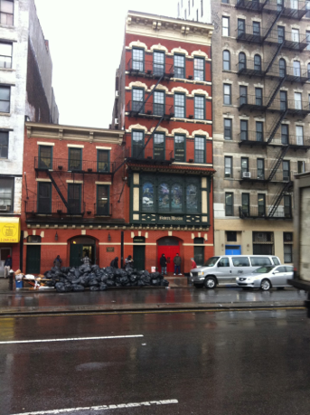
The Bowery became a byword for flophouses, alcoholics, and dank, urban poverty. For decades the Third Avenue El ran above the Bowery, adding a greater sense of darkness to an already depressed area. In the 1870s the Bowery Mission was founded to help the many homeless people, and the Mission continues this work today at 227-229 the Bowery. As I cross Houston Street and head down the notorious stretch of this old road, I am stunned by the first thing I see: a Whole Foods grocery store on the corner, not exactly what I consider a sign of destitution (except when you leave it laden with groceries: it is not called ‘Whole Paycheck’ for nothing). A bit further along the road I pass the Mission. Trash bags are piled up on the street in front of the building, and the people hanging out on the sidewalk in front do not look like they spend much money at the store up the street. This is New York too, the part of New York I dislike, the juxtaposition of extremes of wealth and poverty, where the two halves can be seen simultaneously in close proximity. Things are better than in Jacob Riis’ day but certainly are far from perfect.
*****
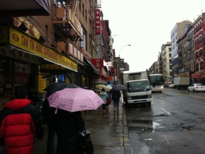
Crossing Delancey, I look left and see the span of the Williamsburg Bridge, the second of the three bridges connecting Manhattan to Brooklyn, completed in 1903. Delancey Street is named for James Delancey, a colonial Lieutenant Governor and a Chief Justice of New York who presided over the Zenger trial in 1735 (mentioned in Entry #59). On a map of the area from the 1750s ‘Lt. Delancey’s’ large estate can be seen along ‘Bowery Lane’ in this area. Today I am no longer in farmland, but rather I am clearly now in Chinatown, as the signs, sights, sounds, and smells all indicate. I am also nearing the one mile mark on the old Post Road, which in the colonial era marked the edge of town. A few blocks ahead at Canal Street I look left again to see another bridge, the Manhattan Bridge, the third and last bridge leading to Brooklyn. Ahead the Bowery begins to curve a little westward, in the area that was the outer edge of New York for much of the eighteenth century. I think I will stop here and begin the next entry on the edge of colonial New York.
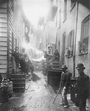
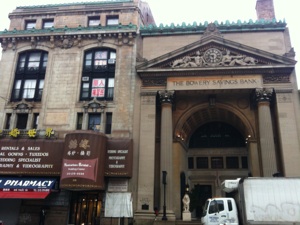
Top left is one of Jacob Riis’s photographs from How the Other Half Lives, a book exposing the poverty of the area around the Bowery. Top right is the Bowery Savings Bank on the Bowery at Grand Street. Built in 1894 by McKim, Mead, and White (Stanford White, he of opulent Madison Square Garden and the ‘victim’ of the ‘Trial of the Century’ in 1907), it stands as an ironic monument on a street known for its connection to poverty. The photograph at left for instance, from 1890, is of a spot only a few yards from the bank. To the west of the Bowery are located what was once the Five Points neighborhood, Little Italy, and Chinatown while to the east is the Lower East Side, all areas of great poverty made infamous by the photojournalism of Jacob Riis in How the Other Half Lives (1890). Bottom left is a view south down the Bowery, near Grand Street, in Chinatown. Bottom right is a view east from Canal Street at the Bowery looking towards the Manhattan Bridge, the last of the three bridges built to connect Lower Manhattan to Brooklyn.
Sunday, April 17, 2011
Walking the Post Road
The Bowery Mission, founded in the 1870s, still provides shelter for the destitute for which the Bowery, this section of the old Post Road, is famous.
“Let us have faith that right makes might, and in that faith, let us, to the end, dare to do our duty as we understand it.”
Abraham Lincoln, from the Cooper Union Address, February 27, 1860.
“This ain’t no Mudd Club, or CBGB, I ain’t got time for that now.”
Talking Heads, ‘Life During Wartime,’ 1979.
Notes
-
1.Gerard R. Wolfe, New York: A Guide to the Metropolis: Walking Tours of Architecture and History (New York: McGraw-Hill, 1983), 247-8.
-
2. Ibid., 240.
-
3. Ibid., 219. Much of what I describe along the walk in this section of New York is based on this book, so I will refrain from repeating ibid.s and just recommend you go and look at the book.
-
4. Knight, 70.
Distance Walked in the Entry: 1.9 miles
Total Distance Walked in New York State: 34.3 miles
Total Distance Walked for this Project (from Boston): 348 miles
Distance Remaining to New York (Bowling Green): 2 miles