Entry #65: Mile 274, New York. The Last Mile.

Today the lower stretch of the Bowery, the old Post Road in this section of New York south of the entrance to the Manhattan Bridge, is firmly planted in Chinatown. The population in this area of New York is, unsurprisingly, heavily Asian. I pass through three census blocks on my way from the Manhattan Bridge to the Brooklyn Bridge near City Hall, and Asians make up about four out of five of the nearly 16,000 residents. The signs on the buildings are in both Chinese characters and in English. Many of these buildings are painted red, a color of good fortune in Chinese culture. One of the buildings along this stretch, at Pell Street, is easy to miss but is one of the few remaining buildings in the area dating to the eighteenth century. On the opposite side of the street is Confucius Plaza, a large ugly modern apartment block near the Manhattan Bridge.
In the late eighteenth century this area was owned by the Delancey family who planned and developed a neighborhood consisting of a grid of streets around what was to be Delancey Square. The grid was built but the square was eliminated from the plan, and the neighborhood east of the Post Road became the Lower East Side. The grid was extended a couple of blocks west of the old Boston Road, or the Bowery as it became known, and this today is Chinatown, settled by immigrant Chinese in the nineteenth century at the northern edge of the notorious Five Points neighborhood. Today Chinatown has escaped its historical boundaries and has even taken over most of Little Italy. As I continue down the last block of the Bowery I can see the beginnings of what looks like a transition to an area of large buildings and the end of the small residential and commercial buildings of Chinatown. As I enter this transitional area I reach the edge of colonial New York City and the final mile of the old Post Road.
*****
Milestone number one is shown on Christopher Colles’s 1792 map at the point where the old road made an abrupt turn to the north. This curve can be seen on eighteenth century, nineteenth century, and even contemporary maps of New York. A wonderful online project called Oasisnyc.net is making a heroic effort to map the entire city block by block including overlays of the topography and the historical land use through the long history of settlement. One set of maps shows the original Lenape footpaths that once criss-crossed the island. One of these became the old colonial road north out of New York City, which eventually became the road to Boston and is the road I have been walking as closely as possible to the original path. This map shows the Lenape trail in lower Manhattan superimposed on a map of the current streets of the city. One thing that immediately stands out is that there was a large body of water around which the Lenape trail passed to the south and east before the trail curved northward. The trail then essentially followed the line of what is today the Bowery as I have been doing (in the opposite direction of course) for the last couple of miles. When the old Lenape Trail reached what is today Madison Square Park it turned to the northeast to take the path of least resistance through the hills and across the streams that once were much more prominent features of Manhattan Island. This is essentially the route I followed across Manhattan.
The streams are mostly gone and many of the hills have been leveled, but the trail created by the feet of the Lenape Indians of Manna-hata (the island of steep hills) still exists here in the most densely populated place in North America, in the financial center of the world, with its soaring towers of commerce, in the neighborhoods that have been transformed from farmland to slums on the edge of town to high-end residential areas to commercial centers back to slums in the middle of a great metropolis and back again into desirable areas to live. The path of the Indians who lived here for hundreds and perhaps thousands of years still exists under all this asphalt and steel and concrete and glass and traffic and has been passed over by literally millions of people on the way to finding the American Dream or to an early death in an overcrowded tenement. The Indians are gone, the forests and streams are gone, most, but not all, of the vestiges of nearly two centuries of colonial New York are gone, as are most of the buildings of the nineteenth and even of the twentieth centuries, but the old path that antedates the recorded history of America is still plainly visible on a map of New York standing out from the grid. I think that is pretty damn cool, and it is the primary reason I have pursued this project.
*****
As I mentioned above, Colles’s map shows the one mile stone at the place the old road curved to the north. This is the spot at which the old trail would have passed around the body of water I mentioned, which was present into the early nineteenth century and was called the Collect Pond. The one mile stone was located at the junction of Division Street and the Bowery in an area called Chatham Square. Today this is in Chinatown and is sometimes referred to as Kim Lau Square, but it has been in existence as a square since at least 1766 as seen from maps of that period. Chatham Square was the center of the cattle market in New York, located as it was at the edge of the city and along the main road into the city. Nearby was a tavern called the Bull’s Head, (what else?) which had a long and interesting life in various locations in the city.
Near Chatham Square on colonial maps of New York (like the one below) tanneries can be seen to the west of the old road near the Collect Pond. The Collect Pond, a spring-fed pond, eventually became polluted by the waste products of the tanneries and slaughterhouses and became a public nuisance, which led to it being filled in with dirt from nearby hills that were leveled in the early 1800s. The area east of the Collect Pond was still swampy, however, and thus was considered insalubrious. Hence it became a place for poor people to settle, and the neighborhood came to be called Five Points, a reference to the intersection of three streets (hence five points, or corners) at the center of the neighborhood. The old Post Road (or Boston Road, or the Bowery) was the eastern edge of this notorious neighborhood (mentioned in my last entry). The first settlers were, unsurprisingly, African Americans, who were in turn succeeded by Irish refugees from the Potato Famine of the 1840s. The neighborhood achieved permanent notoriety in Charles Dicken’s description in his American Notes on a visit in 1842:
"What place is this, to which the squalid street conducts us? A kind of square of leprous houses, some of which are attainable only by crazy wooden stairs without. What lies behind this tottering flight of steps? Let us go on again, and plunge into the Five Points. This is the place; these narrow ways diverging to the right and left, and reeking everywhere with dirt and filth. Such lives as are led here, bear the same fruit as elsewhere. The coarse and bloated faces at the doors have counterparts at home and all the world over. Debauchery has made the very houses prematurely old. See how the rotten beams are tumbling down, and how the patched and broken windows seem to scowl dimly, like eyes that have been hurt in drunken forays. Many of these pigs live here. Do they ever wonder why their masters walk upright instead of going on all fours, and why they talk instead of grunting?"
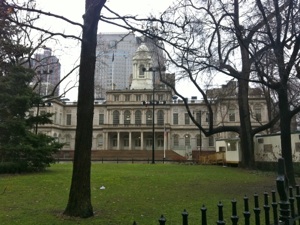
Today Five Points is an unpleasant memory: the city demolished the neighborhood around 1900 and replaced it with administrative buildings for both city, state, and federal governments, collectively known today as the Civic Center. At Chatham Square the Bowery ends, and the old Post Road continues as Park Row, passing through the southern edge of the Civic Center area of New York City, before reaching the entrance to the Brooklyn Bridge, then passing City Hall, and ending at Broadway. Unfortunately, one negative aspect of the events of September 11, 2001 relevant to the Post Road is that the area around the Police Headquarters, which is on Park Row (also called Avenue of the Finest), is now closed to the public for security reasons. Thus I have no choice but to take a detour at this point along the Post Road. The old Lenape trail followed roughly along Park Row mainly to avoid the swampy areas around the Collect Pond, but since the Pond is no more and I have little choice anyway, I head right onto Pearl Street and into Foley Square, through a canyon of city, state, and federal courthouses and administrative buildings. I turn left in Foley Square and head down Centre Street which brings me shortly back to Park Row near the Tweed Courthouse and the lovely City Hall.
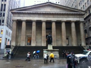
City Hall dates from the same period as the filling in of the Collect Pond. The building was built upon what in colonial New York was the Common at the northern edge of the city, shown on the map below published in 1776. Prior to 1812 City Hall was located on Nassau and Wall Street in what is now the Financial District. The original City Hall became Federal Hall when New York was briefly the capital of the new nation, and then returned to its function as City Hall until the completion of the new City Hall at this point a half mile north. The milestones along the Post Road were measured from the original City Hall, or Federal Hall as it is called on the map of Christopher Colles dating from 1792. When the current City Hall was opened in 1812 the milestones were replaced using the new building as the zero point. This is the source of the often conflicting descriptions of the location of milestones in Manhattan. For instance Milestone 1 is listed in many sources, including Wikipedia, as being on the Bowery, opposite Rivington Street, while on Colles’s map and in many other sources, the first milestone is located at what is now the Bowery at Division Street. The Bowery at Rivington Street is indeed about one mile away from the current City Hall but 1.6 miles from Federal Hall, while the Bowery at Division Street is about one mile from Federal Hall but less than a half mile from today’s City Hall. This location problem continues all the way up the island and, compounded by the opening of the Harlem Bridge and the subsequent rerouting of the Post Road from upper Manhattan through the South Bronx, makes sorting out the original location of the no longer extant milestones difficult and confusing.
*****
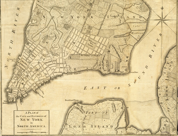
Above is a map of New York City in 1776. This map shows just how small New York City was, with about 25,000 people living in an area extending only about as far north as Chambers Street (below the gardens visible on the map), with some new development in the area north and east of the Collect Pond (labelled ‘Fresh Water’) around the Bowery, in what is now the Lower East Side but which was the Delancey Estate at the time. The Delancey family were Loyalists and thus their property was confiscated after the war. The Common below the Collect Pond is the site of City Hall today. Notice the sweeping curve of the old road to Boston as it passes the Collect Pond and through the Common before heading south as Broadway to the southern tip of Manhattan Island.
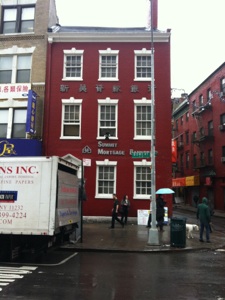
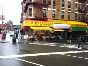
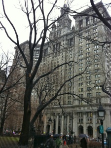
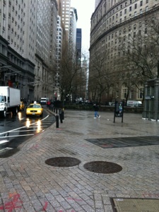
Below are scenes from the last mile of the old Post Road in lower Manhattan. Clockwise from top left: 1. A Federal-era building still stands along the Bowery in Chinatown. 2. Chinatown scene on the Bowery at Division Street, near the Bloody Angle, the center of the Tong wars of early twentieth century Chinatown. This is also the location of the one mile stone on Colles’s 1792 map of the Post Road 3. Manhattan Municipal Building, across from City Hall, was completed in 1914 to accommodate the large increase in the size of the bureaucracy required to run the consolidated City of New York after 1898, when the Boroughs officially became a part of the City and increased the population to over 3,000,000 residents. 4. City Hall, completed in 1812, replaced Federal Hall on Wall Street, and became the new point from which milestones were measured. Located on the site of the Common visible on the 1776 map above.
Park Row continues past City Hall and the entrance to the Brooklyn Bridge, and passes a series of elegant buildings, some of which are now part of the campus of Pace University but which, in previous incarnations, were the offices of many of the newspapers in New York, hence the epithet applied to this section of the old road to Boston, ‘Newspaper Row.’ All of the chief newspapers of the day (including the New York Times before their move to Long Acre, now Times, Square in 1904) had offices here and many well-known publishing figures, including Joseph Pulitzer, Horace Greeley, and William Randolph Hearst, spent long hours shuttling back and forth between their offices here, and the halls of power across the street. It is not an overstatement to say that this was the center of information distribution in America in the nineteenth century.
Opposite City Hall on Broadway is the magnificent Woolworth’s Building, another of my favorite buildings (I would list my three favorite skyscrapers in New York as --3. Flatiron Building, 2. Woolworth Building, 1. Chrysler Building, and all three happen to be on the old Post Road!) Completed in 1913, the Woolworth Building became the tallest building in the world until surpassed by the Chrysler Building in 1930. Only a year later the Empire State Building became the tallest building in the world, a position of primacy it held until 1971, when the Twin Towers of the World Trade Center were completed. The site of these buildings is clearly visible from the corner of Park Row and Broadway, as they were located only one block west of Broadway directly behind the churchyard of St. Paul’s Chapel. Sadly, the Empire State Building is once again the tallest building in New York, and, while more than a dozen buildings around the world have surpassed it as the tallest skyscrapers in the world, it is still 15th on the list after 80 years.
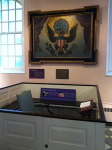
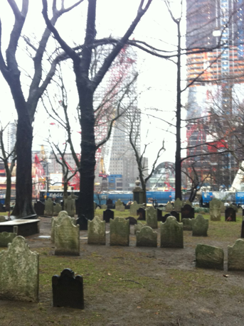
St. Paul’s Chapel is marked on Christopher Colles’s map at the place where the old road takes its final turn, this time due south on Broadway, before it reached the end at Bowling Green, less than 1000 yards away. To Londoners the church should seem familiar as it was based upon the Georgian St. Martin’s-in-the-Field. When completed in 1766 (it is the oldest standing church in New York) it was at the northern end of the growing city. After the Revolution, when New York was the capital of the country for two years, George Washington came here to worship following his inauguration and was a regular parishioner during his time in New York as President of the United States. Inside the church George Washington’s original pew remains, along with many historical relics of the illustrious old building.
The main thing I notice, however, is the large amount of material commemorating the victims of 911; above the main floor, attached to the balcony, are a number of banners from around the country and the world, including a large banner signed by and sent with sympathy from the families of the victims of the Oklahoma City bombing. A few of the many posters, photographs, cards, and letters that once festooned the gates outside are on display in the chapel. A door at the rear of the chapel leads to the churchyard, where the site of the World Trade Center is visible just across the street. Today there is a great deal of construction, but what strikes me is that it still is essentially a hole in the ground after ten years. I had originally generated the idea of walking the Post Road in the summer of 2000. A year later I was still planning to do the project when the planes crashed into the twin towers. Shortly thereafter, I made a promise to myself to commemorate the victims of this senseless attack when I finally arrived at St. Paul’s Chapel, whenever that day should arrive. Ten years and five months after that unforgettable day, I stand in the churchyard for a moment and look at the still unfinished site, light a candle in the chapel, and head out to Broadway and the final few yards of my journey.
*****
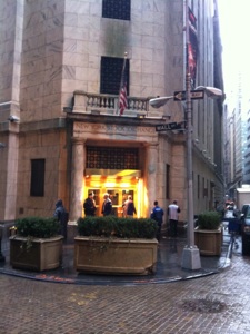
As I head down Broadway in the Financial District of Lower Manhattan it starts to hit me that I am finally walking the last mile of a journey that has taken me from downtown Boston on a tortuous course through the cities, suburbs, farmland, forests, and along the shore of much of Southern New England, through Massachusetts, Rhode Island, Connecticut, and now finally, New York, on a road that for the most part still exists and has existed since before the first European laid eyes on this continent. Perhaps the emotional impact of my visit to the site of the September 11 terrorist attack has also contributed to the upwelling of emotion I feel as I make my way to the end of the road. It is February 25, 2011, at 11:42 a.m. when I find myself standing in front of the Federal Hall Memorial, New York City, the end of the Post Road from Boston. It is raining pretty steadily so any tears streaming down my face are easily concealed from the busy passersby on Wall Street. Perhaps the occasion does not warrant quite such an emotional reaction, but for me the end of this journey is the culmination of over a decade of stop and start planning and research. The walk itself took only a small fraction of the total time I have poured into this project, and to finally be able to say that I did it gives me a feeling of immense satisfaction. But am I really done yet?
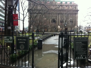
Of course I now face the question that has been bothering for many months as I planned this walk: Where exactly should I end this walk? The end of the Post Road is logically the place where it begins at the other end from where I started, and there is no doubt that Federal Hall was the start of the Post Road in New York City. But if I am following the Lenape trail, the continuation of a string of Indian trails which were the precursors of the Post Road, I surely must follow that trail to the end of its course at the southern tip of Manhattan. Except that the southern tip has changed over the course of the long history of the city by the addition of land extending the shoreline further south than it was in colonial New York or indeed when the Lenape ruled the area. The Bowling Green at the end of Broadway once fronted the harbor, but by the middle of the eighteenth century there was a large fort at the tip of the island, which today is part of Battery Park. Thus, in order to truly say I have finished the walk, I continue a few more yards down Broadway, through the Bowling Green, the oldest public park in New York City, past the statue of the Charging Bull, past the Museum of the American Indian, formerly the Alexander Hamilton United States Custom House, down to the bottom of State Street which was the southern tip of Manhattan in 1609 and marked the end of the Lenape trail, and across Battery Park to the edge of New York Harbor. From here I gaze across the harbor and see the Statue of Liberty and now I know I am done.
I walk along the waterfront toward the Staten Island Ferry Terminal and start to think about another day when I will continue to follow the route of the trip taken by Alexander Hamilton from his home in Annapolis Maryland to this spot and beyond to Boston. Hamilton, James Birket, and especially Sarah Kemble Knight have been my constant companions on this journey, and it is with no little regret that I bid them farewell. I will meet Alexander Hamilton again, but that trip is for another day. So, with a final wistful gaze at the ferry as it heads across the harbor to Staten Island, where a traveler from the colonial era like Alexander Hamilton would have continued to New Jersey, Pennsylvania, and beyond to the rest of America, I turn from the harbor and head back up Broadway, back up the old Post Road, back up the road to Boston, back home.
*****
The Post Road. A name that is easy to forget, a road that is easy to bypass or to dismiss as a vestigial element of some long gone way of life. To do so is to ignore the long course of the development of America that can be easily seen in all its layers of complexity simply by meandering along the old Post Road. For many millions of Americans, the Post Road is just around the corner, a familiar yet almost completely unknown road. Sometimes it is not called the Post Road, but the original road that connected New York to Boston is still there, the road that linked the ‘cities in the wilderness’ that became the political, cultural, and economic centers of the newly established United States, a century and a half after the road was first traveled by early European settlers such as John Winthrop, Jr. I highly recommend a walk along the post road--it is pretty easy to do and I promise you will be rewarded for taking the time to travel deliberately and to see the history of the country, to see the changes over time that have transformed the landscape, to get a sense of the incredible richness of our cultural heritage, or merely to get outside and get some exercise. Walking the Post Road is a heck of a lot more interesting and fun than driving it, that is for sure. And now you have a guide to follow it. Have fun.
The end of the road: Top left: Washington’s Pew in St. Paul’s Chapel on Broadway. Top right is Federal Hall Memorial. Center left: the Bowling Green, with the old Custom House in the background. Center right is the New York Stock Exchange on Wall Street (in case you are the one person on the planet who does not know that fact). Bottom left: Only Jesus could walk any further: The end of the road at New York Harbor, with the Statue of Liberty over my shoulder. Bottom right: Looking back up Broadway from the end of the Post Road. Time to go home.
Tuesday, April 19, 2011
Walking the Post Road
St. Paul’s Churchyard with the site of the World Trade Center beyond.
“The City makes a very fine appearance for above a mile all along the river, and here lies a great deal of shipping.”
Alexander Hamilton, Friday June 5, 1744, on his arrival at New York.
“I left New York with no little regret.”
Sarah Kemble Knight, Thursday December 21, 1704 on her departure from New York.
The number of people I have to thank for their assistance is too large to properly list, but there have been many and I thank all of you for helping me to see this project through to its conclusion. I also want to thank Eric Jaffe both for publishing a book about the Post Road that finally got me out the door and onto the road, and for taking the time to meet with me to discuss our respective experiences on the road. I would also be remiss if I did not acknowledge the deep influence Henry David Thoreau, Luis Bunuel, Carl Bridenbaugh, Carl Schorske, and Jack Kerouac have had in the creation and execution of this project. And to all my friends and relatives who have encouraged me, even when they secretly (and sometimes not so secretly!) thought I was crazy. Special thanks to both of my sisters for their encouragement, but especially Cheryl, who has been a dedicated reader and commentator right from the start. Also to John Tierney whose blog was a source of inspiration for me to do this project, as well as for being a faithful reader. And finally, to those who traveled the Post Road before me and left a record of their journey: John Birket, the Reverend Manasseh Cutler, President George Washington, the inimitable Madam Sarah Kemble Knight, and my personal favorite, Dr. Alexander Hamilton, who traveled the road for his health, and inspired me to do the same.
Finally, this project would never have happened without the encouragement of the love of my life, my wife Dana. I can’t even begin to thank you.
Distance Walked in the Entry: 2.0 miles
Total Distance Walked in New York State: 36.3 miles
Total Distance Walked for this Project (from Boston): 350 miles
Distance Remaining to New York (Bowling Green, Federal Hall, Battery Park, wherever the ‘real’ end of the trip is located): 0 miles. The end.